File:827NLR concrete slab historical.png
From lisamarieyoung.ca
No higher resolution available.
827NLR_concrete_slab_historical.png (470 × 470 pixels, file size: 85 KB, MIME type: image/png)
Summary
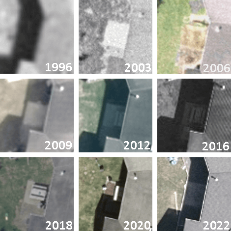
Historical (1996 - 2022) aerial images of the burial location of Lisa Marie Young, 49.14502, -123.97504 adjacent to the back of the house at 827 Nanaimo Lakes Road.
Source: City of Nanaimo Esri® ArcGIS NanaimoMap
, 1996—2022 [1]]]
[Reproduced under Copyright Act (Canada) s.29.2 — Fair Dealing for the purpose of news reporting]
- ↑ Aerial Imagery: City of Nanaimo (1996—2022),
Esri® ArcGIS 'NanaimoMap'
→ For historical satellite photos, change "Base Map" to "All Aerial Imagery"
File history
Click on a date/time to view the file as it appeared at that time.
| Date/Time | Thumbnail | Dimensions | User | Comment | |
|---|---|---|---|---|---|
| current | 06:09, 6 January 2024 | | 470 × 470 (85 KB) | Arielmais (talk | contribs) | Historical (1996 - 2022) aerial images of the burial location of Lisa Marie Young, {{Coords}} adjacent to the back of the house at 827 Nanaimo Lakes Road. Source: <span class="n logo"></span>City of Nanaimo <q>Esri® ArcGIS NanaimoMap</q>, 1996—2022</small> {{NanMap}}]] [Reproduced under Copyright Act (Canada) s.29.2 - Fair Dealing for the purpose of news reporting] |
You cannot overwrite this file.
File usage
The following page uses this file: