Burial
⚠ CAUTION: Information presented on this page is blunt and technical, as it's intended for the BC Coroners Service to aid with the recovery of Lisa's remains. This is the shortest possible version of the facts. There's a lot more to this story, but this is a summary of the details required to physically locate and excavate the clandestine grave.
Victim
- 21-year-old woman of mixed European and Indigenous heritage
- 52kg, 163cm
- long brown hair
- dressed all in black:
- black shirt
- black skirt
- black imitation-leather crop jacket
- distinctive black thigh-high zip-up thigh-high boots
- a belt made up of several heavy 4" stainless-steel rings (~8 gauge × ~4″)
Location
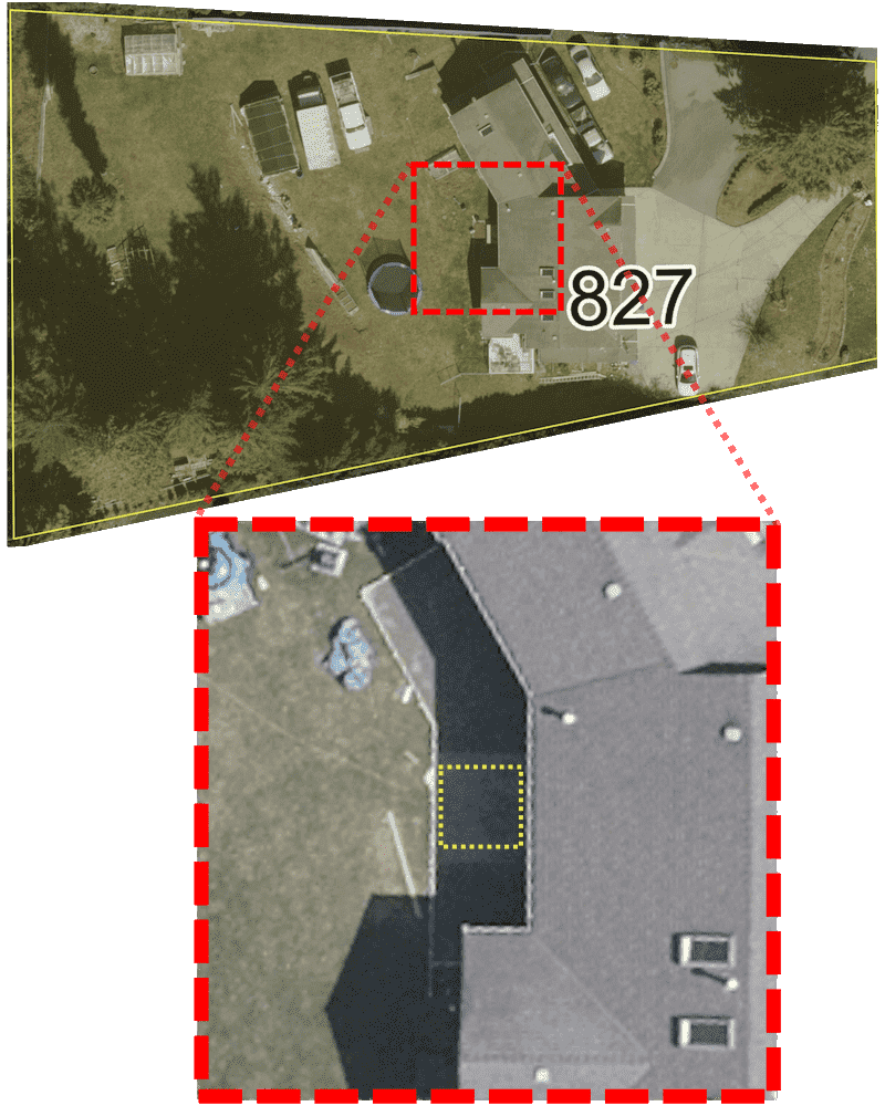
- Precisely 49.14502, -123.97504
- adjacent to the back of the home located at 827 Nanaimo Lakes Road (Nanaimo)
- approx. 8 to 10 feet below a 4ft² concrete slab.
Burial Method
- A deep (possibly 10 feet) hole was dug using a backhoe.
- The backhoe arrived on a trailer towed by a pickup truck.
- The body was tossed in, fully clothed, and the hole was immediately backfilled.
- Witness claims were later corroborated by a neighbour who witnessed the burial.[1]
The victim may have still been breathing at the time that she was buried.
- Witness claims were later corroborated by a neighbour who witnessed the burial.[1]
Concealment
The grave was intentionally concealed using at least two methods:
Concrete
- Immediately after the burial, a 4ft² concrete slab was poured above.
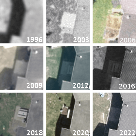
- This witness claim is corroborated by historical aerial imagery showing the addition of the slab between 1999 and 2003.[2]
Garden
- Several months later, the concrete square was covered with soil, and a garden was planted above.
- This witness claim is corroborated by historical aerial imagery showing the addition of a garden sometime prior to 2006.[2]
Unearthed
- Several years later, new owners unearthed the oddly-located and impractically-sized "patio", which has since been home to a wooden picnic table.
- This was deduced based on public records and historical aerial imagery between 2009 and 2018.[2]
- In 2022, a full-sized patio was poured behind the home, incorporating the existing concrete square, which is clearly a different shade compared to the newly-poured area.
- This claim is based on current satellite imagery.[2]
Recovery
Several details should be considered prior to excavation of Lisa's remains:
Detection
- Detection of the remains using Ground Penetrating Radar or a Resistivity method requires removal of the concrete.
- The coordinates provided are precise however the exact depth is unknown.
Thus, it may be helpful to use a metal detector to determine burial depth — the victim was likely buried wearing a belt made up of heavy steel (~4″) rings, and her boots had long ("thigh high") metal zippers.
Equipment
Equipment required for recovery would likely include:
- Concrete saw
- Jackhammer
- Mini excavator (eg., 3-ton, rubber tracks)
- Metal detector (to determine depth)
Aerial Images

Esri® ArcGIS NanaimoMap, 1996-2022 [2]

The square concrete slab is clearly visible in 2003, covered with soil in 2006, seemingly uncovered in 2009, then home to a picnic table. Image Source: City of Nanaimo
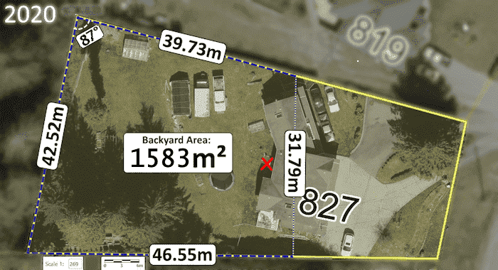
Esri® ArcGIS NanaimoMap[2], 1996-2022

Image Source: City of Nanaimo
Esri® ArcGIS NanaimoMap[2], 1996-2022
Additional property details
- The backyard of 827 Nanaimo Lakes Road is approximately 1,583m².
- BC Assessment info
- Municipal Property Info
- Building Permit
Bedrock Conditions
Often exposed, the area bedrock is comprised of conglomerate and gritstone, minor sandstone, siltstone and carbonaceous shale and coal.[3] This is due to the presence of the Chase River Fault.
Soil Conditions
The area has high clay content[3] and soil in the area is made up of glacial till generally overlying bedrock.[3]
Climate
Average monthly precipitation varies from 24mm in July, to 193mm in December. 77% of annual rainfall occurs during the 6 months of October to March.[4]
On average, Nanaimo has 180 frost free days per year (50%) mid April to late October.[4]
Chase River Fault
The Chase River Fault, a strike-slip tectonic fault line bisects Colliery Dam Park, forming a geological boundary, and appears to continue directly below the burial location.[3][5]
See Also
- List of issues with the official investigation
- More about 827 Nanaimo Lakes Road
- Why RCMP's search of this property failed despite use of Ground Penetrating Radar and a "police dog"
- Timeline: July 1, 2002
- News Article List
Sources
- ↑ Kendall Hanson, CHEK News (Dec 17, 2020),
Nanaimo RCMP conduct new searches in nearly two-decade-old case
(source) - ↑ Jump up to: 2.0 2.1 2.2 2.3 2.4 2.5 2.6 Aerial Imagery: City of Nanaimo (1996—2022),
Esri® ArcGIS 'NanaimoMap'
→ For historical satellite photos, change "Base Map" to "All Aerial Imagery" - ↑ Jump up to: 3.0 3.1 3.2 3.3 Golder Associates, City of Nanaimo (2015),
Factual Geotechnical Report for Colliery Dams Remediation Project
(PDF, 277 pages) (Local copy) - ↑ Jump up to: 4.0 4.1 J.R. Jungen et al, Ministries of Environment, Agriculture & Fisheries, Government of British Columbia (1989),
Soils of Southeast Vancouver Island
(PDF, 226 pages) (Local copy) - ↑ Nick Doe, Gabriola Historical & Museum Society (2009), "Gabriola's structural geology" (PDF, 15 pages) (Local copy)