File:Chase-River-Fault-Nick-Doe-yellow.png
Chase-River-Fault-Nick-Doe-yellow.png (450 × 350 pixels, file size: 48 KB, MIME type: image/png)
Summary
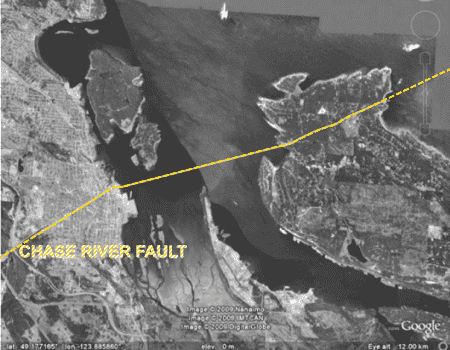
Satellite image highlighting the path of the Chase River Fault, as documented by Nick Doe.
source: Nick Doe, Gabriola Museum (January 21, 2012), Gabriola’s shape — including some surmises
The strike-slip tectonic fault which bisects Gabriola Island and passes under downtown Nanaimo, then along the path of the Chase River and the reservoirs that make up the Colliery Dam.
The Chase River Fault is expected to play a significant role in a massive Magnitude-10+ earthquake, which seismologists say has a 30% of chance of striking Vancouver Island within the next 50 years.
[Reproduced under Copyright Act (Canada) s.29.2 — Fair Dealing for the purpose of news reporting]
File history
Click on a date/time to view the file as it appeared at that time.
| Date/Time | Thumbnail | Dimensions | User | Comment | |
|---|---|---|---|---|---|
| current | 20:03, 13 December 2023 | | 450 × 350 (48 KB) | Arielmais (talk | contribs) | Map highlighting the path of the Chase River Fault, as documented by Nick Doe. Gabriola Museum (January 21, 2012) "Gabriola’s shape — including some surmises" (PDF) Source: https://www.nickdoe.ca/pdfs/Webp220c.pdf The strike-slip tectonic fault which bisects Gabriola Island and passes under downtown Nanaimo, then along the path of the Chase River and the reservoirs that make up the Colliery Dam. [Reproduced under Copyright Act (Canada) s.29.2 - Fair Dealing for the purpose of news reporting] |
You cannot overwrite this file.
File usage
The following 2 pages use this file: