RCMP's improper GPR usage rendered scan useless
Summary
RCMP's December 2020 search of the property at 827 Nanaimo Lakes Road utilized new technology
such as ground penetrating radar (GPR) and a police dog
.
Unfortunately, there are several apparent issues which would have significantly reduced the usability of the GPR scan data.
December 2020 search
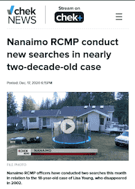
CHEK News, Dec 17, 2020 (Kendall Hanson)[1]
On December 16, 2020, RCMP investigators performed a search of the property at 827 Nanaimo Lakes Road — the same location as the first house party to which Lisa was brought on Canada Day 2002.[note 1]
Police aren't saying what they were looking for but confirm the search was in relation to the disappearance in 2002 of 21-year-old Lisa Young. Police conducted one search at the Nanaimo Lakes Road property Wednesday and the other earlier this month.
[1]
Police have employed modern technology to assist with the investigation including the use of a police dog and ground-penetrating radar.
Cpl. Muntener also said the searches were based on new and historical information.[5]
The efforts failed to locate any sign of Lisa — several external factors may have reduced the effectiveness of the GPR scans.
GPR overview
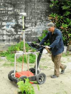
ResearchGate (Jul 2021) Ian Moffat [6]
Ground Penetrating Radar works by using a powered downward-facing antenna to transmit radio waves into the ground. The waves bounce back from obstructions in the ground and are then received by a second antenna for processing. Different types of material will reflect the radio waves at different rates. Many factors can affect the maximum possible depth that the radio signals will travel, and also the rate at which the signals are returned.
Learn more → 3-minute crash course on GPR
Technical principles
GPR is a non-intrusive/non-destructive method of surveying the sub-surface, usually to investigate underground utilities such as concrete, asphalt, metals, pipes, cables or masonry. This method uses electromagnetic radiation in the microwave band (UHF/VHF frequencies) of the radio spectrum and detects the reflected signals from subsurface structures.
The principles involved are similar to seismology, except GPR methods implement electromagnetic energy rather than acoustic energy, and energy may be reflected at boundaries where subsurface electrical properties change rather than subsurface mechanical properties as is the case with seismic energy.
GPR scan issues

GPR scans do not produce a 'picture' of what's underground.
Example GPR scan image, ResearchGate
Ground Penetrating Radar is complex. When using GPR to search for human remains, expertise is needed during the operation of the equipment and for post-processing and interpretation of the images produced; The scan does not produce a "picture" of what's underground.
Water saturation
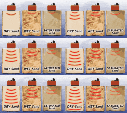
GSSI Geophysical Survey Systems, Inc.[7]
GPR is significantly less effective when used to scan wet or saturated ground.[8]
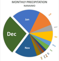

As of the day of the RCMP's search, it had rained 27 of the previous 30 days, including the previous 11 days in a row.[10]
On average, December is, by far, the wettest month in Nanaimo. The ground would have been thoroughly saturated — as most residents of the Pacific Northwest would expect[9] — and it would have remained saturated for weeks afterwards.
This fact on its' own would have likely rendered GPR scan data useless.
Considering the search was already delayed 18 years, it may have been more prudent to hold off a few more months to allow for optimal search conditions, rather than executing the search on what was essentially the wettest day of the year.
Clay content
Special GPR considerations are needed when used on soil with a high clay content, as clay absorbs GPR signals, skewing results.[8]
Geological studies of the area show that soil in the vicinity of Colliery Dam Park has very high clay content.[11]
It is unknown whether this was taken into consideration during the searches — although it seems unlikely considering the list of other GPR-related oversights.
Mineral content
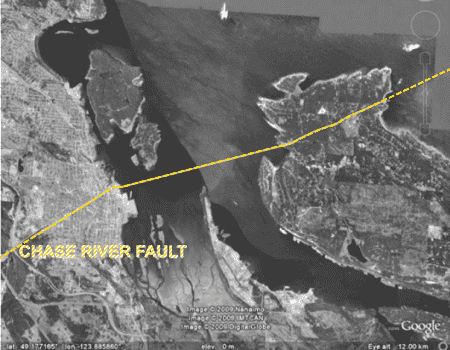
Gabriola Museum, (Jan 21, 2012) Nick Doe[12]
A seismic geological "slip/strike" fault line called Chase River Fault
bisects Nanaimo, running through the centre of the 2 lower dams at Colliery Dam Park, then passing directly under the property at 827 Nanaimo Lakes Road before continuing south, eventually joining with the San Andreas Fault. The Chase River Fault' may have significance to seismologists’ prediction of Vancouver Island’s upcoming “Big One” which is expected to bring a Magnitude-10 earthquake within the next 50 years.
The presence of the fault below the property may indicate an increased concentration of trace minerals which could skew scan accuracy.
The presence of the fault line below the properly could potentially affect the use of Ground of exposed or nearly exposed bedrock due to past ancient seismic activity (such as visible in the park’s “rock formations”). As a result, the soil has a high concentration of pyrite… and soil with a high concentration of metallic minerals can skew radar scan results if not properly accounted for by the GPR operator.
The fault line (and the resultant nearly exposed bedrock in the area) may also limit the maximum possible “grave-digging depth” (if bedrock exists near the surface at the location).
- “Gabriola’s structural geology” (Nick Doe) University of British Columbia Source
- Lower Colliery Dam site geological report (Golder & Associates), July 28, 2015 Source
While this likely has no relevance to the task of locating Lisa Marie Young but was nonetheless interesting to find that the location where she’s buried does indeed hold some significance as a “focal point” of seismic energy.
Scan duration
| ← 30m → | 280 linear metres | ||
| ↑ 40m ↓ |
= 9.6 linear km | ||
| @ 1.5 linear km/hour | |||
| = 6.3 hrs/pass | |||
| x 2 passes (minimum) | |||
| = 12.6 hours |
The amount of time required to properly scan a specific area can be easily calculated with a standard formula provided by GPR manufacturers. A scan of an area the size of the backyard of the home should have taken about 12.6 hours — under ideal conditions. Less-than-ideal conditions increase the time required to achieve usable data.
[13]
RCMP investigators were reportedly present on-site for approximately 6 hours.
(See also: backyard measurements.)
Concrete slab
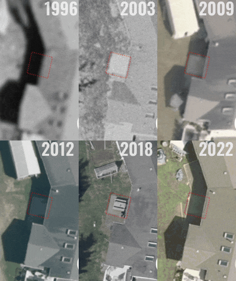
City of Nanaimo NanaimoMap, 1996-2022 [14]
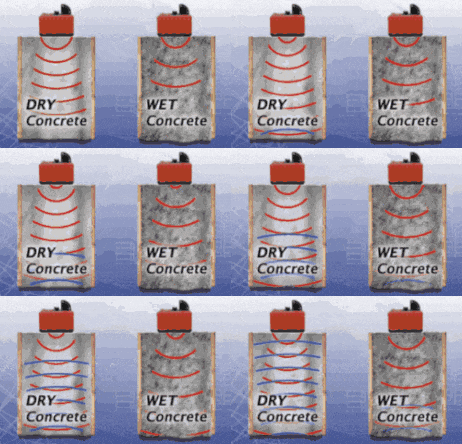
GSSI Geophysical Survey Systems, Inc.[7]
The author learned details of Lisa's burial from a credible source who was present at the time. Lisa was buried adjacent to the back of the home at 827 Nanaimo Lakes Road, beneath the 4ft² concrete slab.[15] The information was then independently verified using a variety of methods and reputable sources.
But, even setting that knowledge aside, there's still a list of reasons that it would be prudent to take a closer look at the concrete slab in the backyard.
- Based on historical satellite photos, the slab did not exist when the home was first built — but was added between 1999 and 2003.
- The 4ft² concrete square would be too oddly located and impractically sized to be useful as a patio, although it did eventually become home to a wooden picnic table.
- The neighbour reported seeing construction equipment working in the backyard around the time of Lisa's disappearance.[1]
- Also documented by historical satellite imagery, the concrete was later concealed by the addition of soil and planting of a garden above, as it remained for a few years until new owners again unearthed the concrete square.
- Another witness living near the home at the time reportedly saw a backhoe moving Lisa's body in the backyard. It's conceivable that a 4ft² concrete square could be used to conceal a hole dug by a small backhoe.
GPR is commonly used for scanning within concrete to detect structural faults such as cracks or voids. This works because the GPR radio waves do not pass through concrete but instead bounce back to the receiving antenna. For this reason, GPR cannot scan through concrete and into the ground below — especially not more than 1 to 2 inches.[16]
Standard operating procedures of various law enforcement agencies (including the US Department of Justice, and the Edmonton City Police) state that, in situations where burial below is suspected, concrete must be removed to allow for effective scanning with GPR.
The concrete was not excavated, as demonstrated by current satellite imagery.[note 2][8]
For even just that one reason alone, the RCMP's GPR scan would have been ineffective.
Other technical issues
All these issues demonstrate that the individual operating the equipment was likely inexperienced in the use of GPR. It's a complex process, and expertise is required, especially when used to locate human remains.
- Data should be post-processed and re-analyzed.[17]
- A transect spacing of 0.25m is recommended optimal spacing for a forensic search.[8]
- Under ideal conditions, "a GPR antenna with a central frequency selected for utility locating and scanning in average soils can typically see within a range of 3-6 feet in many parts of the U.S."[18]
Notes
- ↑ This December 16, 2020 search[1] took place:
- ↑ A full-size concrete patio was added to the property in 2022, however comparison of bi-annual historical satellite photos of the property clearly shows that the new patio included the existing concrete square. The newer concrete is clearly a different shade than the 20-year-old square.
See also
- 827 Nanaimo Lakes Road
- GPR scan area, measured
- Timeline: July 1, 2002
- RCMP misled the public: "Police Dog" vs Cadaver Dog
- RCMP vs Crime Stoppers
Sources
- ↑ 1.0 1.1 1.2 1.3 Kendall Hanson, CHEK News (Dec 17, 2020),
Nanaimo RCMP conduct new searches in nearly two-decade-old case
cn20201217 - ↑ Fort McMurray Today (July 10, 2002),
Foul play suspected in missing B.C. woman
fmt20020710 - ↑ Paul Walton, Nanaimo Daily News (July 10, 2002),
Police fear local met with foul play
ndn20020710 - ↑ Paul Walton, Nanaimo Daily News (Sep 18, 2002),
Grim Task: Police comb woods for Lisa Young
ndn20020918 - ↑ Karl Yu, Nanaimo News Bulletin (June 26, 2021),
Nanaimo RCMP use new information & technology in case of missing woman Lisa Marie Young
nnb20210626 - ↑ Ian Moffat, ResearchGate (July 1, 2021), "Typical GPR unit in use. GSSI SIR 4000 GPR with a 400 MHz antenna"
- ↑ 7.0 7.1 GPR GIF Animations (2021), GSSI Geophysical Survey Systems, Inc.
- ↑ 8.0 8.1 8.2 8.3 John J. Schultz, Ph.D, U.S. Dept of Justice (April 2012),
Detecting Buried Remains Using Ground‑Penetrating Radar
doj20120401 (PDF, 235 pages) (Local copy) - ↑ 9.0 9.1 9.2 J.R. Jungen et al, Ministries of Environment, Agriculture & Fisheries, Government of British Columbia (1989),
Soils of Southeast Vancouver Island
(PDF, 226 pages) (Local copy) - ↑ Environment Canada, Government of Canada,
Daily Data Report for December 2020
- ↑ Golder Associates, City of Nanaimo (2015),
Factual Geotechnical Report for Colliery Dams Remediation Project
(PDF, 277 pages) (Local copy) - ↑ Nick Doe, Gabriola Historical & Museum Society (2009), "Gabriola's structural geology" (PDF, 15 pages) (Local copy)
- ↑ GPR Training Courses,
GPR Survey Time
- ↑ Aerial Imagery: City of Nanaimo (1996—2022),
Esri® ArcGIS 'NanaimoMap'
→ For historical satellite photos, change "Base Map" to "All Aerial Imagery" - ↑ This information was provided directly to the author by a credible, reliable source who was present. ✎ Sworn declaration can be provided as needed.
- ↑ Enhanced Scanning (December 2020),
Now You See It, Now You Don't: Ground Penetrating Radar Depth Explained
- ↑ Tughan Telatar, GeoSpatialWorld (May 21, 2018),
Why is post processing GPR data important?
- ↑ Enhanced Scanning (December 2020),
Now You See It, Now You Don't: Ground Penetrating Radar Depth Explained