File:Patio-vertical-outline.gif
Patio-vertical-outline.gif (154 × 275 pixels, file size: 114 KB, MIME type: image/gif, looped, 10 frames, 25 s)
Summary
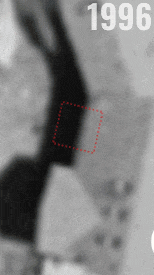
Historical satellite images showing Lisa's burial location from 1996 to 2022, beneath the 4ft² concrete slab located at "49.14502, -123.97504" adjacent to the back of the residence at 827 Nanaimo Lakes Road. The concrete square was added after Lisa's 2002 burial, was for some years concealed by a garden, and in 2022 became incorporated in a newly poured full-size patio (but the 20-year-old concrete is still noticeable due to discoloration).
Commissioned by the City of Nanaimo's Planning Department
Source: https://nanmap.nanaimo.ca
Map: https://www.google.com/maps/place/49.14502,-123.97504/@49.14502,-123.97504,19z/data=!3m1!1e3
[Reproduced under Copyright Act (Canada) s.29.2 - Fair Dealing for the purpose of news reporting]
File history
Click on a date/time to view the file as it appeared at that time.
| Date/Time | Thumbnail | Dimensions | User | Comment | |
|---|---|---|---|---|---|
| current | 19:51, 13 December 2023 | | 154 × 275 (114 KB) | Arielmais (talk | contribs) | Historical satellite images showing Lisa's burial location from 1996 to 2022, beneath the 4ft² concrete slab located at "49.14502, -123.97504" adjacent to the back of the residence at 827 Nanaimo Lakes Road. The concrete square was added after Lisa's 2002 burial, was for some years concealed by a garden, and in 2022 became incorporated in a newly poured full-size patio (but the 20-year-old concrete is still noticeable due to discoloration). Commissioned by the City of Nanaimo's Planning Dep... |
You cannot overwrite this file.
File usage
The following page uses this file: