File:827-Nanaimo-Lakes-Road-GPR-area-measured.png
827-Nanaimo-Lakes-Road-GPR-area-measured.png (700 × 380 pixels, file size: 70 KB, MIME type: image/png)
Summary
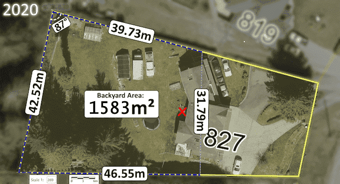
Aerial image (with measurements) of the burial location of Lisa Marie Young, 49.14502, -123.97504 adjacent to the back of the house at 827 Nanaimo Lakes Road showing the approximate/maximum area scanned with Ground Penetrating Radar by RCMP investigators during their December 16, 2020 search. The quadrilateral area totals roughly 1583 m².
Source: City of Nanaimo Esri® ArcGIS NanaimoMap
(2022) [1]
See also: RCMP's improper GPR usage rendered scan useless
[Reproduced under Copyright Act (Canada) s.29.2 — Fair Dealing for the purpose of news reporting]
- ↑ Aerial Imagery: City of Nanaimo (1996—2022),
Esri® ArcGIS 'NanaimoMap'
→ For historical satellite photos, change "Base Map" to "All Aerial Imagery"
File history
Click on a date/time to view the file as it appeared at that time.
| Date/Time | Thumbnail | Dimensions | User | Comment | |
|---|---|---|---|---|---|
| current | 22:00, 30 April 2024 | | 700 × 380 (70 KB) | Arielmais (talk | contribs) | The approximate/maximum area scanned with Ground Penetrating Radar by RCMP investigators during their December 16, 2020 search of the backyard of the residence at 827 Nanaimo Lakes Road. The quadrilateral area totals roughly 1583 m². See also: RCMP's improper GPR usage rendered scan useless [Reproduced under Copyright Act (Canada) s.29.2 - Fair Dealing for the purpose of news reporting] |
You cannot overwrite this file.
File usage
The following page uses this file: